Condamine road trip
If it’s been a few months since you have gotten some dirt on the tyres, I highly recommend a day trip to Condamine River – a 4WD track near Killarney.
Our expectations were high, with every website boasting its 14 river crossings, scenic views and the Condamine Gorge which floods from time to time. Truth is, the Condamine River Track is only 20km long so if you’re planning to spend the day there I suggest choosing a picnic destination close by. We chose to stop by Lake Moogerah for lunch on the way home and it was amazing. Make sure you plan ahead because if the region has had a lot of rain there’s a chance the track could be closed.
The drive
Our road trip began in Brisbane and we drove to Boonah where we had a quick rest stop to stretch our legs. From Boonah we headed for the track. Here are some directions to get there from Boonah.
- Travel out on Rathdowney Road and in 3.4km turn right onto Alford Road.
- 13.4km turn left onto Dwyers Road.
- 21.2km turn right onto Carney’s Creek Road.
- 28.2km turn right onto The Head Road.
- 46.4km turn right onto Condamine River Road.
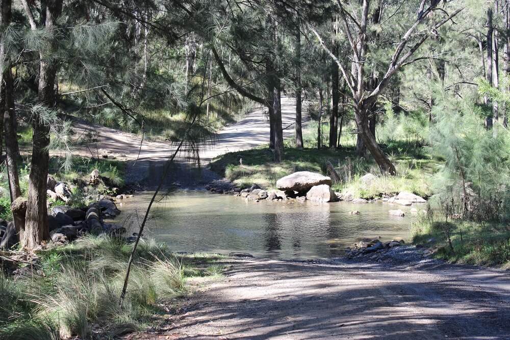
Condamine River track
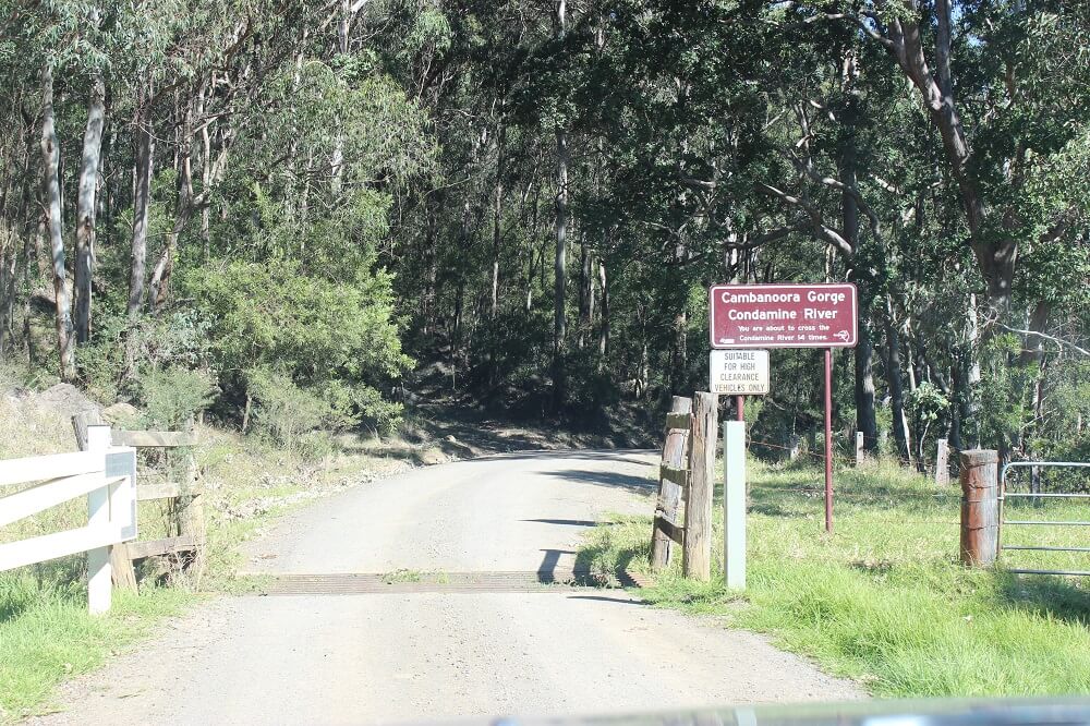
The Condamine River Track is 20km long and crosses the Condamine River 14 times. It’s the perfect track for four-wheel drive beginners who are looking to enhance their water crossing skills.
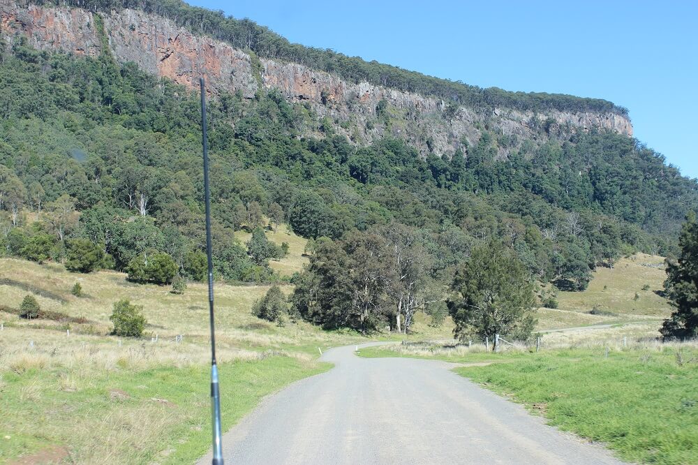
The roads leading up to the track are narrow and windy, so take it slow and keep a distance from tree branches to avoid scratches. Cattle will also be casually roaming the area, so be aware of random cattle grids.
It is recommended that you have a high-clearance 4WD vehicle to tackle the track, as the road is gravel with a variety of large potholes. Some crossings are very rocky, so drive slowly to avoid any dints.
It’s important to check the conditions of the track beforehand, because if the region has had a lot of rain there will be flooding and some crossing may be too deep.
The main highlight of the track is the spectacular scenery surrounding you.
Lake Moogerah
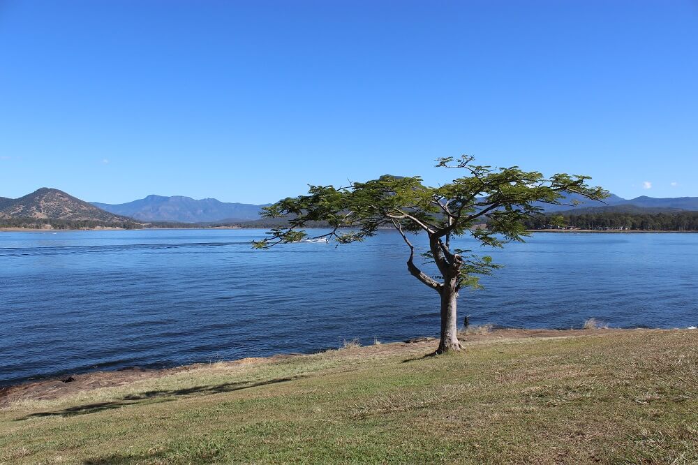
About an hour’s drive into our road trip home we decided to stop at Lake Moogerah for a picnic. This a great place to stop for families as there is a small café, toilets and tables and chairs overlooking the lake.
The park also provides access to the dam wall, which you can walk across to take some great photographs of Lake Moogerah. On the other side of the dam wall is Mount Edwards – a walking track which leads to a lookout and downhill to another picnic area.
Essentials
- Vehicle needed: 4WD
- Trip time: Day trip
- Distance: 128km
- Fuel supplies: Boonah, Killarney
- Warnings: The Condamine Gorge can flood so check road conditions after rainfall.
- Camping: Available at Killarney View Cabins & Caravan Park, Queen Mary Falls Caravan Park & Café (pet friendly), Boonah Show Society Caravan Park

More articles
Related topics
Things to note
The information in this article has been prepared for general information purposes only and is not intended as legal advice or specific advice to any particular person. Any advice contained in the document is general advice, not intended as legal advice or professional advice and does not take into account any person’s particular circumstances. Before acting on anything based on this advice you should consider its appropriateness to you, having regard to your objectives and needs.
Insurance Products (excluding Travel Insurance) are issued by RACQ Insurance Limited ABN 50 009 704 152 (RACQI) and arranged by RACQ Distribution Services Pty Ltd (RDS) ABN 35 116 361 650, AFSL 567130 and RDS' authorised representatives (including RACQ Operations Pty Ltd ABN 80 009 663 414, AR No. 234978 (RACQO)). Conditions, limits and exclusions apply.
Any advice provided by RDS and RACQO is general advice only and does not take into account your personal objectives, financial situation or needs and you will need to consider whether the advice is appropriate for you. Read the Product Disclosure Statement (PDS) before making a purchase decision on the product. You can also access our Target Market Determinations on this website.
RDS receives a commission from RACQI for the policies it arranges. RACQO receives fees paid for services it provides to RDS. Further details about remuneration are available on request prior to purchasing.
Banking and loan products issued by Members Banking Group Limited ABN 83 087 651 054 AFSL/Australian credit licence 241195 trading as RACQ Bank. Terms, conditions, fees, charges and lending policies apply. This is general advice only and may not be right for you. This information does not take your personal objectives, circumstances or needs into account. Read the disclosure documents for your selected product or service, including the Financial Services Guide and the Terms and Conditions, and consider if appropriate for you before deciding.
Except for RACQ Bank, any RACQ entity referred to on this page is not an authorised deposit-taking institution for the purposes of the Banking Act 1959 (Cth). That entity’s obligations do not represent deposits or other liabilities of RACQ Bank. RACQ Bank does not guarantee or otherwise provide assurance in respect of the obligations of that entity, unless noted otherwise.
RACQ Bank subscribes to the Customer Owned Banking Code of Practice which establishes higher standards than the law requires. The Code reflects modern consumer expectations and developments in approaches to issues such as consumer vulnerability, guarantors, and supporting customers through financial hardship. Please read our Customer Owned Banking Code of Practice page for more information.
RACQ Operations Pty Ltd (ABN 80 009 663 414, AR No. 234978) and Members Travel Group Pty Ltd (ABN 45 144 538 803, AR No.432492) (RACQ) are authorised representatives of the RACQ Travel Insurance insurer Tokio Marine & Nichido Fire Insurance Co., Ltd. (ABN 80 000 438 291 AFSL 246 548) (Tokio Marine). Tokio Marine Management (Australasia) Pty Ltd (ABN 69 001 488 455, AR No. 1313066) is an authorised representative of Tokio Marine, and administers RACQ Travel Insurance as the managing agent on behalf of Tokio Marine. Terms, conditions (including eligibility criteria), exclusions, limits and sub-limits apply. Any advice is general advice only, and does not take into account your specific objectives, financial situation or needs. Before you purchase, please consider the Combined Product Disclosure Statement (PDS) / Financial Services Guide (FSG) and Target Market Determinations (TMDs) available at racq.com or on request from RACQ.